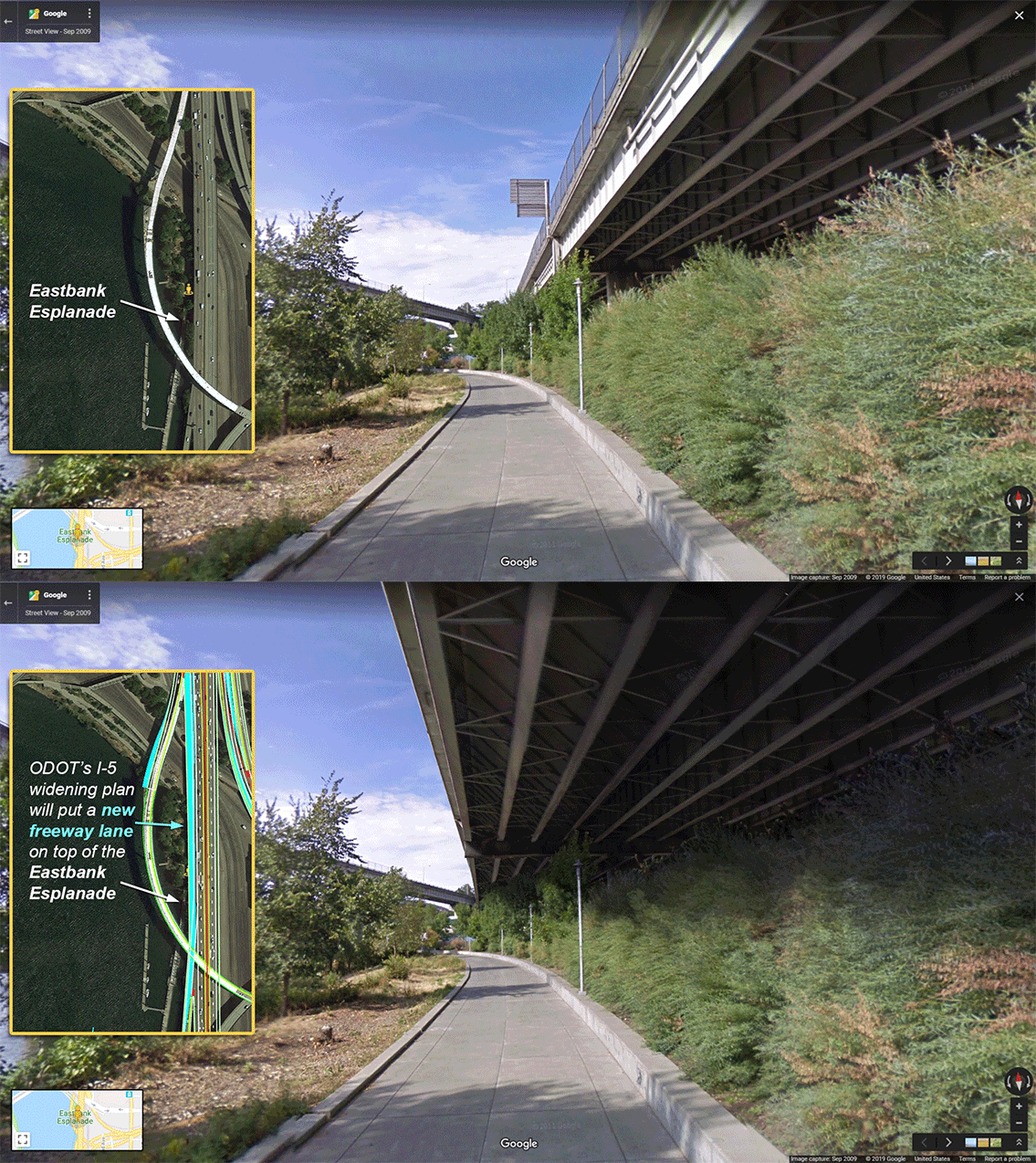
Graphics by Cupola Media via No More Freeways PDX.
With so many inconvenient truths brought to light recently about the Oregon Department of Transportation’s plans to expand the I-5 freeway, one of the most disturbing is the fact that it would cast an even larger shadow over the Eastbank Esplanade.
The Esplanade, opened in 2001 and named for former Mayor Vera Katz in 2004, is a beloved piece of carfree infrastructure that hugs the western edge of the freeway. It runs between the Steel Bridge in the north and OMSI (SE Caruthers Street) to the south and provides a safe option through the Central Eastside Industrial District. Even though it’s carfree and just yards from the Willamette River, the noise and toxic emissions from drivers using I-5 is ever-present.
That’s why it’s so troubling that ODOT’s I-5 expansion plans would increase the freeway’s negative impacts on the Esplanade.
On page 61 of the Environmental Assessment (whose comment period closes at 4:59 pm this Monday April 1st), ODOT informs us that, “The Build Alternative would also require the acquisition of a 0.11–acre permanent surface easement from the Eastbank Esplanade along the western edge of the SB ramp from I–5 to I–84. The easement would be needed to provide potential intermittent access to the ramp by ODOT maintenance crews. Temporary, periodic closures of the park within the boundaries of the permanent easement may be required to accommodate ODOT maintenance activities.” This permanent easement is in addition to “periodic temporary occupation of segments of the Vera Katz Eastbank Esplanade” during project construction that is likely to lead to several closures of unknown duration.

Thanks for reading BikePortland.
Please consider a $10/month subscription or a one-time payment
to help maintain and expand this vital community resource.

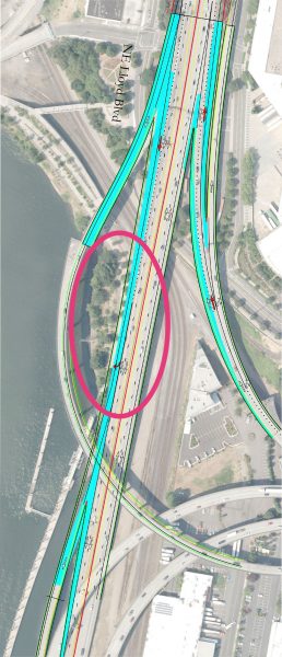
Cyan color is proposed new lanes. The floating dock of the Esplanade is in the lower left. Area in animation is circled. (Source: ODOT via Iain MacKenzie)
Portlander Iain MacKenzie (with an assist from lawyer Alan Kessler) added considerable flesh to this information by asking ODOT for detailed engineering drawings of the project. MacKenzie made the request on February 15th, the first day of the EA comment period. After a public records request, ODOT finally released a trove of project files on March 26th, just a few days before the end of the comment period. MacKenzie has made the files available to the public via Twitter.
Using those drawings, MacKenzie and Aaron Brown with No More Freeways PDX hired local video simulation firm Cupola Media to create a graphic that shows how the new lanes on I-5 will impact the Esplanade (see lead GIF image).
And this was just one detail of the project that was broadly exposed this week. Both City Observatory and Oregon Public Broadcasting dug deeper into a very interesting project nugget: That all the project’s key projections about traffic and emissions were based on an assumption that a mega-project to expand I-5 between Oregon and Vancouver (like the Columbia River Crossing) would be built. Not only is a new CRC not even on the table, but the fact that ODOT used it to cook their books to make the I-5 Rose Quarter project look better is sneaky at best, and bureaucratic malfeasance at worst.
The longer this project is exposed to an informed public, the more reasons we have to distrust ODOT.
Please consider sharing your thoughts by commenting on the EA (you can submit as many as you’d like). I no longer trust ODOT enough to send you to their website, so if you want to comment please visit https://nomorefreewayspdx.com/publiccomment/.
— Jonathan Maus: (503) 706-8804, @jonathan_maus on Twitter and jonathan@bikeportland.org
Never miss a story. Sign-up for the daily BP Headlines email.
BikePortland needs your support.
The post ODOT’s I-5 freeway widening project would cast even larger shadow over Eastbank Esplanade appeared first on BikePortland.org.
from BikePortland.org https://ift.tt/2FJYE8w

No comments:
Post a Comment